The earthquake was at a depth of 33 km
Local time at epicenter: Tuesday, Jan 11, 2022 12:35 am (GMT -11)
Magnitude: 6.8
Depth: 22.3 km
Epicenter latitude / longitude: 52.6563°N /167.9169°W (North Pacific Ocean, Alaska, United States)
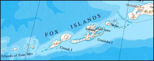
Antipode: 52.656°S / 12.083°E Nearest volcano: Recheschnoi (70 km / 43 mi)
Nearby towns and cities:
71 km (44 mi) ESE of Nikolski (pop: 18)
164 km (102 mi) SW of Unalaska (pop: 4,490)
165 km (102 mi) SW of Dutch Harbor (pop: 4,380)
217 km (135 mi) SW of Akutan (pop: 1,040)
384 km (239 mi) SW of False Pass (pop: 40)
441 km (274 mi) SW of Cold Bay (pop: 123)
454 km (282 mi) SW of King Cove (pop: 1,010)
Tectonic Setting:
The Aleutian Islands region, where Pacific plate is being forced under the North American plate, is one of the world’s most active seismic zones. In 1957, magnitude 8.6 Andreanof Islands earthquake ruptured a ~600 km-long portion of the plate boundary in the central Aleutian Islands. The June 24, 2011 M7.3 earthquake is located in the central part of the 1957 rupture zone. In 1986, a portion of the western half of the 1957 zone failed in an earthquake of magnitude 7.9. In 1996 another magnitude 7.9 earthquake appear to have completed re-rupture of the western end of the 1957 zone, immediately westward of the 1986 region. No other major (magnitude 7 or greater) earthquakes occurred within the 1957 rupture zone up until June 24 event. Depth and faulting type of the June 24 earthquake is consistent with it being an intraslab earthquake, i.e. it occurred inside the subducting Pacific plate rather than on the plate interface.
