No Tsunami alert issued after 7.3-quake strikes southern Indonesia
A strong earthquake with a preliminary magnitude of 7.3 has struck the Flores Sea in southern Indonesia, prompting tsunami alerts for nearby coastlines, seismologists and residents say. Only few details are currently available.
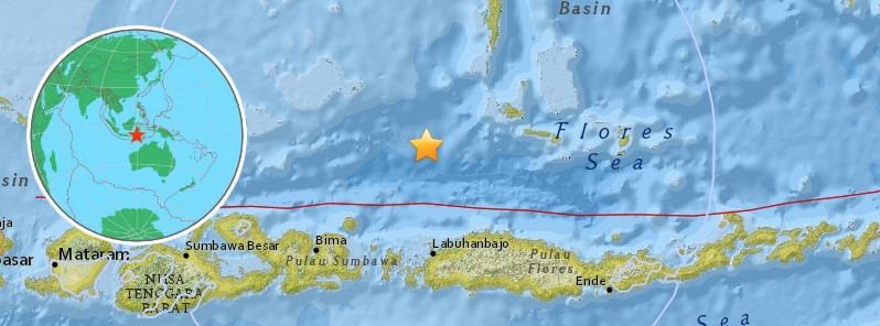
The earthquake, which struck at 11:20 a.m. local time on Tuesday, was centered in the Flores Sea, about 100 kilometers (62 miles) north of Maumere, one of the largest towns on Flores Island, which is west of Timor-Leste (East Timor).
Indonesia’s seismological agency BMKG put the preliminary magnitude for Tuesday’s earthquake at 7.4 with a depth of just 12 kilometers (7.4 miles). The U.S. Geological Survey (USGS) put the magnitude at 7.3, down from an earlier reading of 7.6, at a depth of 18 kilometers (11 miles).
A tsunami warning which was immediately issued for nearby coastlines was later downgraded to an advisory. People in the area should be told to move away from the beach but no evacuations are required, BMKG said. There’s no threat of a Pacific-wide tsunami.
BMKG’s earthquake and tsunami mitigation coordinator, Daryono, said small tsunami waves had been recorded in the Flores Sea.
The USGS estimates that up to 21 million people could have felt Tuesday’s earthquake, of which 347,000 people may have felt “moderate” shaking and 2,000 people “strong” shaking. Details about damage or casualties, if any, were not immediately available.
Indonesia is on the so-called ‘Pacific Ring of Fire’, an arc of fault lines circling the Pacific Basin that is prone to frequent and large earthquakes.
